Tuesday, November 13, 2007

Hedgehog Mountain - 2532'

The UNH Trail up Hedgehog Mountain takes off from a mid-Kancamagus trailhead. After a week of rain the lower third of the trail was a layer of squishy leaves--and a cold 40 degrees. Our clockwise ascent seemed to be the easiest route on this loop though it seemed the dozen or so other people we encountered were going counter-clockwise. Some nice steep ledge near the top.

Muh checking out some beautiful lavender moss.


How cold was it? Well, those are icicles on the rock by Muh's knees.


The ridge to its southeast and Mt. Passaconaway (right).


Muh resting and looking out at Mt. Paugus and Chocorua over its left shoulder.


Prior to heading up to Allen's Ledge Duh had to do a weak Sideshow Bob impersonation.


A spectacular view from the top. Tripyramid here:


And an already snow-covered Mt. Washington.


White Lake

Duh's back was the victim of a lawn mowing accident which kept us on flat ground this week. We checked out Madison Boulder believing that there were some conservancy trails in the area. Finding none, it was off to Plan B at White Lake State Park.

Madison Boulder is believed to be one of the largest eratics in the world. We read somewhere that one of the likely sources of this boulder is White Ledge--about four miles away.

Muh never felt so small! Unfortunately, the boulder is coverd in grafiti.


With Duh on the DL Muh had to play Colby Mule. Cute as a button.


We've been sort of surprised at the lack of wildlife sightings in the WMNF. On today's walk around White Lake, however, we saw a couple of (skittish) loons, a colossal and very active woodpecker, and Vanna's beaver lodge here:


I don't know why but there were several trees along the shore blown over--hanging and growing over the water. Here's a good shot of Mt. Whittier which we were surprised to find out is next to the old Mt. Whittier ski area which is evidently not on Mt Whittier but Grant Peak.


White Ledge Redux

While our favorite son was home for fall break we wanted to take him for a hike so we brought him up to White Ledge--familiar territory. On our previous trip we started at the trailhead within the WMNF White Ledge Campground. This time we took off from the alternate trailhead a half mile or so further north on Route 16.

Muh was very happy to have the boy alone for the trip.


The color was still pretty good.


Arj inspecting the White Ledge Cache. His first.


Muh's hero!

Duh's hero. (Duh is not doing a Michael Jackson impersonation.) You can't see the scorched skull here, but today we learned that sunscreen is needed even in late October. What you can see is a good shot of Mt. Chocorua.


Tuesday, October 23, 2007

Square Ledge-Lost Pond

The extra-long drive to the AMC's Pinkham Notch visitor's center did not disappoint. We checked out the free naturalist activity of the day (who knew porcupines were members of the weasel family?) before heading across Route 16 to Square Ledge and Lost Pond Trail. It was a very busy leaf-peeper weekend. We thought we had it rough parking in the overflow lot...these folks had to park on Rt16.


The view across Rt16 toward the AMC visitor's center and Mt. Washington from Square Ledge. It's hard to take a bad picture in the Whites.


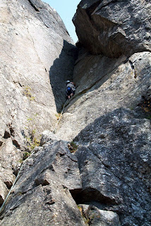
Square Ledge is a big training ground for rock climbers. Here we look down from the top at some chap in white helmet readying himself for the climb (top) and then looking back up at him from below (bottom).


Square Ledge definitely packs a lot of vertical for such a short hike. This is a trail with a purpose! Muh demonstrates how to not be bothered by dust and pebble covered steep granite on the descent.


Is there a better place for a tree to set root?


Lost Pond Trail is pleasant trail to nowhere. No vertical change to speak of but plenty of hopping rock to rock. "Found" Pond and view.


While sitting at Lost Pond we could hear the Cog Railway arrive at Mt. Washington's summit. Here you can see the engine's smoke drifting over the summit.


Thursday, October 4, 2007

Mt. Pemigewasset - 2533'

After our previous trip to The Flume something seemed to be left undone--Mt. Pemigewasset. It also made for an easier hike after last week's Welch-Dickey trip. The hike up the Mount Pemigewasset Trail was an easy steady climb. What an inviting view at the top! These ledges continue to be unsettling to Duh. The trail empties out at this ledge. When we got there a young woman was snapping pictures right on the point--a 100' drop...with 20mph gusts!


The southern view had a nice look at I93 snaking through Lincoln, NH.


Mr. Scaredypants a lot further away from the edge than it looks.


Lots of color coming out.


Off to the east, across I93, Mount Liberty (left) and Mount Flume--a peak-bagging adventure for next year. You can't really make it out, but Mount Liberty is supposed to look like George Washington laying in state.


And Loon to the Southeast.


We took the Indian Head Trail on the way back. This tree climbing over this boulder reminded us of a creepy Tim Burton movie.


A fungus "flower" for Lauren. It had little teeny rubbery fingers like a Kooshball.


We made a huge tactical error and hiked counterclockwise today. BAD plan. The hike from the Indian Head Trail trail head back to the Mount Pemigewasset Trail trailhead was 1.2 miles...300' vertical...uphill. So, in the long run, today's hike was no less tiring than Welch-Dickey. Indian Head's namesake from Rt 3--pretty cool.

Monday, September 24, 2007

Dickey Mountain - 2631'

We got to play peak-baggers today with Dickey so close to Welch. The second half of the Welch-Dickey Loop starts with a bang! Here you can see Dickey from the top of Welch...and Muh contemplating how to get there. That is a sheer drop off that she's looking at and the trail blaze indicated you needed to walk parallel to that cliff! Fortunately, by taking one more step toward the edge you could see the rest of the trail off to the left--a great relief. Frankly, we're wondering why you never hear of people getting killed out here. There are plenty of opportunities!


The cool nights have started to bring some color out in the trees. This is the back side of Welch from Dickey. If you look carefully you can see people at the summit.


Welch Mountain - 2339'

Back to the White Mountain National Forest's west side. The Welch-Dickey Loop takes off from the trail head just off Route 49. There were quite a few cars in the parking lot--we were sure to have company on the trail today.

The first 800' of vertical was almost effortless thanks to a twenty minute break for a phone call from Arj. The second 800' was mostly steep open granite ledge. Very challenging for us! Easily the toughest terrain thus far. Thankfully it was dry. Had it been wet we would have retreated.

There was a nice view just before the final ascent that showed off Sandwich Mountain and the Sandwich Range overlooking Route 49..


Turning left gave you a good shot at Welch's summit and Muh, the volunteer family portrait photographer.


The trip up Welch had us scrambling over and squeezing between granite slabs. This passage was about 20" wide, 15' deep, and about 8' vertical change front to back.


Thursday, September 20, 2007

Oak Ridge

A rare Monday off encouraged us to go to Castle in the Clouds in Tuftonboro for an easy day. Beautiful location on Lee Mountain. Queer house. Tragic ending for the Thomas Plant story is about all I can say.
Muh checking out the waterfall leading up to the "castle":


A nice trail map of the Ossipee Range provided by Lakes Region Conservation Trust gave us high hopes for many hikes to come. Our first effort on the Oak Ridge Trail was very disappointing. You could have driven an eighteen-wheeler up the trail!


Lucknow from Oak Ridge:


Duh admiring the view of Gunstock on the other side of Winnipesaukee:


The major trailhead at Shannon Pond features "Feed the giant trout"--these trout are 3 times larger than any trout I've ever seen!


The ducks were equally fond of the Trout Chow.


White Ledge Loop

Oh boy--what a great trip! Our best yet.

With rain eminent, we headed off to EMS and got some rain gear Friday night. One more step to being real hikers :-) Saturday we headed off for the White Ledge Campground in Albany. The White Ledge Loop Trail took off from the back of the campground. Last week we did Boulder Loop, northeast of Chocorua. White Ledge is southeast.

What a great trail! We manage to miss most of the rain, but the rain gear came in handy nonetheless.


An intermittent stream near the trailhead. Definitely there Saturday after the rain:


This is not an intermittent stream. This is water gushing down the ledge trail! (And some rain on the lens.) There were several spots where we actually had to stop and think about how we were going to get from point A to point B. That was a first for us. And fun.


Near the top of the ledge. This is a lot steeper than it looks!


The view from the top of the ledge (the opposite viewpoint from the previous picture).


Muh checking out the GPS looking for the White Ledge cache. (Note the purdy rain shell.)


On the return trip the look eastward over Iona Lake (left) and Whitton Pond hiding behind Whitton Ledge.


Two hours up. One hour down. Just a little over 4 miles and 1400' vertical.

We stopped a few miles down Route 16 and found the Albany Moose Lookout Cache. Here's a big cache of moose to look out for that we found near the cache.