The extra-long drive to the AMC's Pinkham Notch visitor's center did not disappoint. We checked out the free naturalist activity of the day (who knew porcupines were members of the weasel family?) before heading across Route 16 to Square Ledge and Lost Pond Trail. It was a very busy leaf-peeper weekend. We thought we had it rough parking in the overflow lot...these folks had to park on Rt16.
The view across Rt16 toward the AMC visitor's center and Mt. Washington from Square Ledge. It's hard to take a bad picture in the Whites.
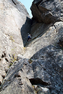
Square Ledge is a big training ground for rock climbers. Here we look down from the top at some chap in white helmet readying himself for the climb (top) and then looking back up at him from below (bottom).
Square Ledge definitely packs a lot of vertical for such a short hike. This is a trail with a purpose! Muh demonstrates how to not be bothered by dust and pebble covered steep granite on the descent.
Is there a better place for a tree to set root?
Lost Pond Trail is pleasant trail to nowhere. No vertical change to speak of but plenty of hopping rock to rock. "Found" Pond and view.
While sitting at Lost Pond we could hear the Cog Railway arrive at Mt. Washington's summit. Here you can see the engine's smoke drifting over the summit.
Tuesday, October 23, 2007
Thursday, October 4, 2007
Mt. Pemigewasset - 2533'
After our previous trip to The Flume something seemed to be left undone--Mt. Pemigewasset. It also made for an easier hike after last week's Welch-Dickey trip. The hike up the Mount Pemigewasset Trail was an easy steady climb. What an inviting view at the top! These ledges continue to be unsettling to Duh. The trail empties out at this ledge. When we got there a young woman was snapping pictures right on the point--a 100' drop...with 20mph gusts!
The southern view had a nice look at I93 snaking through Lincoln, NH.
Mr. Scaredypants a lot further away from the edge than it looks.
Lots of color coming out.
Off to the east, across I93, Mount Liberty (left) and Mount Flume--a peak-bagging adventure for next year. You can't really make it out, but Mount Liberty is supposed to look like George Washington laying in state.
And Loon to the Southeast.
We took the Indian Head Trail on the way back. This tree climbing over this boulder reminded us of a creepy Tim Burton movie.
A fungus "flower" for Lauren. It had little teeny rubbery fingers like a Kooshball.
We made a huge tactical error and hiked counterclockwise today. BAD plan. The hike from the Indian Head Trail trail head back to the Mount Pemigewasset Trail trailhead was 1.2 miles...300' vertical...uphill. So, in the long run, today's hike was no less tiring than Welch-Dickey. Indian Head's namesake from Rt 3--pretty cool.
Subscribe to:
Posts (Atom)